Eighteenth Century Coastal Maine

 Despite Maine’s rich natural resources, settlement was hard and dangerous, and coastal towns grew slowly through most of the 18th century. Conflicts with Native Americans and their French allies discouraged English settlers from moving up the coast east of the Penobscot River. When the Battle of Quebec in 1759 ended the French presence on the Maine coast, settlement began to increase in midcoast and downeast Maine, but the American Revolution brought more hardships, including British occupation and attacks by British privateers.
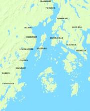
Despite these obstacles, towns emerged around Penobscot Bay. These dates are from “The Length and Breadth of Maine.”
| Present Day Town | Date Settled |
| Penobscot & Brooksville | 1760 |
| Blue Hill and Deer Isle | 1762 |
| Sedgwick and Brooklin | 1763 |
| Frankfort | 1760 |
| Prospect | 1739 |
| Camden, Belfast, Rockport, Islesboro | 1769 |
| Northport and Lincolnville | 1780 |
| Thomaston | 1733 |
| Waldoboro (Broad Bay) | 1717 |
| Warren | 1736 |
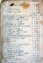
Shubael Watson was the owner of a store in Brooklin (then called Naskeag.) His account book lists transactions as far back as 1762. It includes expenses for a trip to Salem, Massachusetts, a center of colonial commerce.
Maine’s islands were settled before the mainland: Monhegan and Damariscove Islands were among the earliest. In 1790 the populations of Vinalhaven, Mount Desert, and Deer Isle were greater than Bangor, Belfast, and Camden.
Interior towns were more isolated and matured more slowly than coastal communities.

