Geographic Locations

Popham Beach Bathers

This photo is from the James E. Perkins collection. It shows a group of what were probably summer visitors to Maine, enjoying Popham Beach, sometime in the 1920s.

Marseilles Harbor, 1880s-Quai de la Fraternite

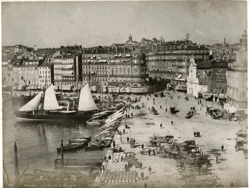
This albumen print depicts a large vessel at anchor at the Quai de la Fraternite, port of Marseilles, France. Quai means "dock" or "embankment" in French. Source: www.mkpix.org/gallery2/main.php/v/seetheworld/europe/france/photos1800s. Used with permission.

Marseilles Harbor 1880s

This albumen print depicts Marseilles Harbor in the 1880s. Source: www.mkpix.org/gallery2/main.php/v/seetheworld/europe/france/photos1800s/. Used with permission.

Map of Micronesia

Micronesia refers to a region in the Pacific Ocean containing thousands of small islands. It lies east of the Philippines and northeast of Indonesia. Some of the island groupings within Micronesia are the Caroline Islands, the Gilbert Islands, and the Mariana Islands. Micronesia is distinct from Melanesia to the south and Polynesia to the east. This image is from Hammond's Unabridged Atlas and Gazeteer of the World, published by C. S. Hammond & Co., Inc., New York, 1924, page 90. (Collections of Penobscot Marine Museum)

Society Islands

The Society Islands are a group of islands in the South Pacific Ocean, part of French Polynesia. They were named by Captain James Cook. The most well known of these islands is Tahiti.

This image is from Hammond's Unabridged Atlas & Gazeteer of the World, published by C. S. Hammond & Co., Inc., New York, 1924, page 91. (Collections of Penobscot Marine Museum)

Merithew House

Built by Captain Jeremiah Merithew in 1826, this house is now an exhibit building belonging to Penobscot Marine Museum.

Main Street, Searsport, L. W. Edwards' shop

The shop sign "L. W. Edwards" can be seen on the left side of the street in this early photo of Main Street in Searsport, Maine. Look above the first floor windows of the three story brick building. The sign is dark colored and sits just above the white band. Lucy Edwards had a millinery shop in town as far back as the Civil War era. She was trained to use the first telegraph in Searsport and would announce the news of the War from in front of her shop.

Sakhalin Island

Sakhalin Island is a large island in the North Pacific Ocean, just north of Japan and close to the eastern coast of Russa. It is owned by Russia, but has historically been the subject of territorial disputes between Russia and Japan.

This image is from Hammond's Unabridged Atlas & Gazeteer of the World, published by C. S. Hammond, New York, 1924. (Collections of Penobscot Marine Museum)

Sicily

Sicily is the largest island in the Mediterranean Sea. It is an Italian autonomous region and lies just off the southernmost tip of Italy. This image is from Hammond's Unabridged Atlas & Gazeteer of the World, published by C. S. Hammond & Co., Inc., New York, 1924. (Collections of Penobscot Marine Museum)

Adriatic Sea

The Adriatic Sea is the body of water separating Italy from the Balkan peninsula, which includes the present-day countries of Bosnia-Herzegovina, Albania, Croatia, Montenegro and Slovenia. The Adriatic is the northernmost arm of the Mediterranean Sea. This image is from Hammond's Unabridged Atlas & Gazeteer of the World, published by C. S. Hammond & Co., Inc., New York, 1924, page 50. (Collections of Penobscot Marine Museum)

Pages

Subscribe to RSS - Geographic Locations